

Exploring Porlock Weir
- Russ

- Aug 9, 2020
- 2 min read
The British summer is guaranteed to keep you on your toes and waking up on the last weekend in July to the sound of heavy rain on the van roof was not altogether surprising. Donning hiking boots and waterproof coats we set off through the Somerset lanes and headed for the coast. There is no better place to watch the weather rolling in than the beach and pulling into the car park at Porlock Weir the sky opened up in front of us.


The beach at Porlock Weir is remarkable; the shingle and pebble ridge was formed over 600 years ago and creates the longest continuous barrier system on the western coast of Britain. Stretching for five kilometres with the Bristol Channel on one side and the inland sea marsh on the other, the barrier was breached by the sea during the October storm of 96 allowing the marsh to be flooded at every high tide.


Setting off eastwards from the harbour at Porlock Weir we walked along the ridge until we had to head inland around the edge of the sea marsh.
This diverse area is a Site of Special Scientific Interest, covered in numerous types of lichen, sea kale and samphire it provides a home to many seabirds.
Crossing over the small streams that wander across the marsh we reached the intersection with the footpath heading northwards to the village of Porlock and the small boardwalk leading back down to the ridge. If you head further west you can continue to Bossington but, with the clouds returning we decided to make our way along the beach back towards Porlock Weir. As is so often the case we decided to pass the sign on the beach warning of the breach and it wasn’t long before we realised that perhaps we should have paid a little more attention to the sign! Having said that the breach is certainly worth seeing.


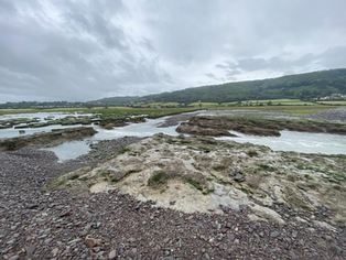


We were on the beach at low tide but the water was still rushing from the marsh and through the channels that have been carved through the ridge, to the sea.
Turning westwards we crossed back over the board walk retracing our steps part of the way back along the marsh. A little less than halfway along, we turned inland, following a footpath that led us up to the road connecting Porlock and Porlock Weir.


After a few hundred yards on the road heading back, we took a steep footpath that ran up between the houses until it reached the treeline on the hills behind. The short climb was well worth the effort as the additional height gave lovely views across the marsh and out to sea. The path ran along the back of the gardens, crossed over a small stream and then took us down into Porlock Weir again.

Returning to the van we took our picnic to a bench on the nearby beach and had lunch whilst watching the clouds creep along the coast towards us. Despite the rather dismal weather we could see the Welsh coastline across the channel and agreed to return on a brighter day next time we visited the area.


We'll see you down the trail


Comments